Noosa Shire’s annual planned burn season began earlier this month with Weyba Nature Refuge.
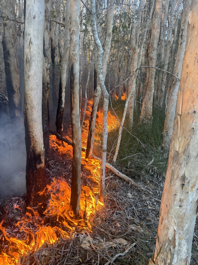
The first burn of the season was successful with about 6.4 hectares of vegetation comprising Eucalypt and Melaleuca Woodland cleared.
Noosa Council fire management officer Shaun Harris and the team have been working hard to plan and prepare for the fire season ahead, monitoring the weather conditions closely.
“Prolonged rain has resulted in high soil and fuel moisture, allowing officers to ”coolburn” the nature refuge kicking off the planned burn season a little earlier than previous years,” he said.
“Low intensity patch mosaic burning is used to reduce the impact on native animals and larger native trees to achieve the desired ecological outcomes.
“This allows animals to escape through the unburnt edges and natural features such as gullies and generally leaves 25 to 60 per cent of an area unburnt, providing animals with areas for refuge.
“We also rake around the base of significant animal habitat trees and those with important cultural values to ensure these trees are protected from the fire – some are hundreds of years old – and undertake pre and post-fire monitoring on vegetation and associated wildlife habitat.
“Periodic fires play a crucial role in the well-being and resilience of our forests and the creatures that inhabit them. Over 85 per cent of the council’s bushland depends on fire for its vitality, regeneration, and the sustenance of robust wildlife populations. These fires are essential for maintaining ecological balance and supporting species that have evolved to coexist with them.”
Noosa North Shire, Pomona, Ringtail Creek, Sunrise Beach, Doonan, Noosaville and Tewantin will undergo burns before September, if conditions are suitable.
“Residents near the nominated burn locations should keep an eye out for advance notice of activity in their area, keep windows and doors closed when burns are planned and ensure any respiratory medications are close to hand,” Shaun said.
“Again, this season, council will collaborate with other agencies such as the Queensland Fire and Emergency Services and the Queensland Parks and Wildlife Service undertaking regional fire mitigation planning, disaster management and fire operations.
Stay up to date:
· Notice of upcoming burns will be placed on Noosa Councils Facebook page facebook.com/noosacouncil.
· Sign up to ‘Noosa Alerts’ to receive text messages related to planned burns in your area and other local disaster events disaster.noosa.qld.gov.au/.
· Search ‘bushfire management’ on council’s website sunshinecoast.qld.gov.au.
· For permit to burn maps head to qfes.qkd.gov.au/prepare/bushfire/permit-to-burn-map.
Residents who live adjacent to the burn locations will receive a notification letter prior to controlled burns in their area.
Signage on the surrounding streets will be in place in the days before the burn.
All burns follow conditions issued under a Queensland Fire and Emergency Services’ permit to light fire.
Planned burns are dependent upon strict weather conditions and resourcing.
Community safety:
Any threats to life and property, call 000 (triple zero).
Any residents affected by smoke are advised to close windows and doors, utilise air-conditioning and keep respiratory medication close at hand. Seek medical advice if you are susceptible to smoke impacts.
As a precaution, road users are advised to drive to suit conditions as there is potential for smoke to reduce visibility.


