
As Noosa residents keep watch on Noosa Spit amid concerns of waves breaking across the sand dunes, at last Friday’s Noosa Park’s Association environment forum botanist Sue Aspland spoke about the extraordinary channel carved through Bribie Island over a 12-hour period on 2 January during the remnants of Cyclone Seth.
Sue told guests records dating back to the 1940s had indicated considerable movement on the sand island.
In 1958 records showed the island had migrated significantly southward and the Pumicestone Passage entrance had moved during 1942-61, while a previous breakthrough had occurred during twin cyclones in 1954.
Sue said a research project undertaken in 2000 identified the loss of 144,000 cubic metres of sand a year on the island with an estimated 30,000 cubic metres disappearing due to longshore drift.
The 2000 report predicted that due to the loss of sand a breakthrough could occur in 20 years, she said.
Sue said while working with Sunshine Coast Council in 2006 storm surge overtopping led to the formation of a Bribie Island breakthrough taskforce and she assisted in setting up monitoring points.
“Council was monitoring four areas on the island where there could be a breakthrough,” she said.
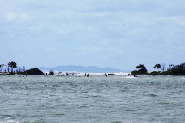
On 2 January 2022 waves carved a channel through a Bribie Island and surged into Pumicestone Passage near Golden Beach.
A resident of Golden Beach Sue said on hearing the loud roar of the sea all night she knew the breakthrough had occurred and rushed to the site in the morning recording events from 8.27am.
“I stood for one hour and could not believe what I was seeing,” she said. “2.5m of spit was eroding every five minutes. It was so rapid. By 9am a solid patch of vegetation had gone. There was no stopping it.”
When news spread of the event people in jet skis and boats came to see what was happening.
“The entrance was 50m wide after 12 hours.” In the past six months it has widened to an estimated 550 metres, creating a north and south Bribie Island.
Sue said debate continues over whether the changes to the island have been nature or human induced.
Since the 1960s hypotheticals for nature induced changes have noted the erosion of beaches and dunes, loss of vegetation, the increased southward movement of the island and the movement of Pumicestone passage boating channel, she said.
Potential human induced actions have included increased shipping and resultant wake of large propellers, 20 years of dredging and the impact of urbanisation including increased tourist and recreational use. Sue said sand stores had been removed to build structures on the Port of Brisbane and airport runway and the conversion of mangroves to canals and stormwater runoff had diverted much water that would have seeped into the ground but not flowed through pipes to the sea.
The changes have caused a loss of habitat, loss of cultural heritage sites as well as navigation changes and residential impacts.
She said the Caloundra Coast Guard can no longer gain access from north to south of Pumicestone Passage and Pelican Waters moorings cannot easily access the ocean. In addition some areas of Pelican Waters have experienced flooding which has not previously occurred.
Sue said with records dating back only about 100 years it is unknown whether such an occurrence is a cyclical event.
Research is about to commence on identifying all possible causes of the breakthrough and subsequent impacts on Pumicestone Passage, the adjoining mainland and habitat-dependent native species.


