The Noosa Shire is leading innovation, using technology and research to improve environmental outcomes and find solutions for the future.
Encompassing the boundaries of the Noosa Shire, plus three kilometres offshore, the Noosa Biosphere Reserve is situated in a unique place that is rich in biodiversity, culture, community – and science.
The Noosa Biosphere is one of 738 areas in the world recognised by UNESCO as a place where thriving communities and sustainable development sit alongside active conservation, science and innovation.
Noosa Biosphere Reserve Foundation’s program manager, Garry Hamilton says the Noosa Biosphere is a place for learning.
“Our biosphere is an environment where people collaborate to create, test and explore ideas – in a real-world setting. We are literally in a real-life living laboratory,” he said.
“When research happens in real environments, the solutions are able to tackle today’s challenges and implement solutions for the future.”
Explore some of the real-world examples of how our Noosa Biosphere is embracing smart technology for conservation outcomes, in Noosa’s living laboratory.
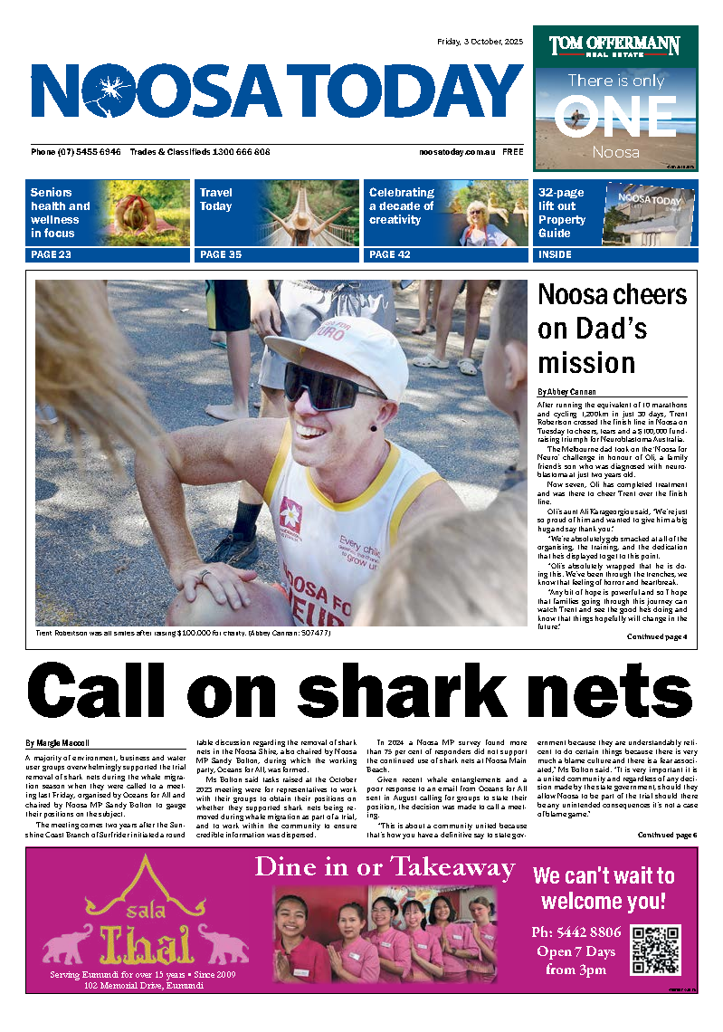
Detecting koalas using AI and drone technology
Noosa and District Landcare is part of the WildSeek project: Community and Artificial Intelligence for Wildlife – a partnership between NSW Wildlife Information Rescue Education Service (WIRES), Queensland University of Technology (QUT) and Landcare Australia.
The aim of this project is to bring together expertise, knowledge and create and support a National Conservation AI Network of Community Hubs for the conservation and rescue response of native species.
QUT has developed a highly effective method for drone survey flights specifically designed to detect Koalas using thermal imagery data which is then fed into an artificial intelligence algorithm that can identify unique Koala heat signatures.
By following the method outlined by QUT, Noosa Landcare has completed multiple flights within the Noosa Shire using their drone, to collect baseline data on Koala populations which is shared with the AI network.
This space is growing rapidly and it’s exciting that Noosa Landcare is contributing to a more accurate representation of Koala populations within Australia.
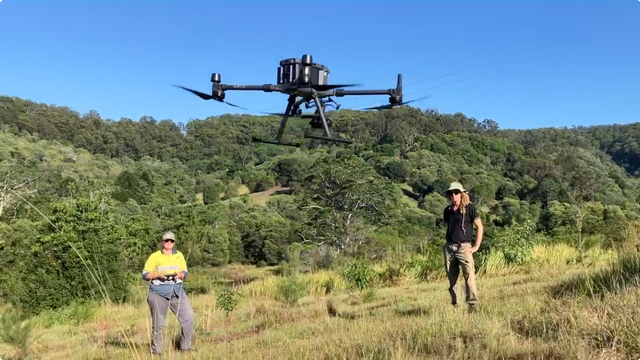
Glossy Black-Cockatoo sound recording
Monitoring of Glossy Black-Cockatoo habitat is ongoing across the Noosa and Sunshine Coast Biosphere Reserves using bioacoustic sound recorders to detect the birds’ calls.
The south-eastern Glossy-Black Cockatoo is the smallest of the black cockatoos with the most selective feeding habits and is listed as threatened under the Environment Protection and Biodiversity Conservation Act. Due to habitat destruction and other human influences, the population is in decline.
Very little is known about the movements of these birds, specifically their preferred nesting sites. A better understanding of the behaviour, flight paths, feed tree sites and nesting hollows present an opportunity to implement conservation strategies aiming to increase breeding success and reduce the destruction of their feed trees.
Bushland Conservation Management is monitoring the varying calls of the Glossy Black-Cockatoo to identify locations of feeding and nesting. Bioacoustic sound recorders are positioned in known hotspots and set to record at a specified time, morning and evening. They use a stand-alone Glossy Black-Cockatoo call recogniser with real-time notifications and daily sound clip file synchronisation.
Receiving Glossy Black-Cockatoo detection data in real-time and the use of AI technology allows for bigger datasets to be collected over large remote areas with less human resources and no influence on bird behaviour.
Residents are also able to submit Glossy Black-Cockatoo sightings at www.bushlandconservation.com.au
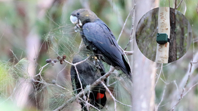
Keeping Kin Kin’s soil in place
The Kin Kin Catchment covers an area of approximately 205km2 consisting of a number of minor tributaries that run into Kin Kin Creek. Keeping it in Kin Kin is a soil remediation project aimed at keeping Kin Kin’s soils in place.
The Noosa and District Landcare led project uses LiDAR technology to determine hot spots of erosion, and the imagery indicates what type of erosion has occurred. Remote sensing Light Detection and Ranging uses pulsed laser light to detect variable distances on the earth’s surface. By comparing images dating over a specified period, changes in elevation of soil can be analysed.
Working to mitigate erosion prone areas will see an improvement of waterway health and water quality within the Noosa River and Lake Cootharaba systems and an increase in agricultural productivity.
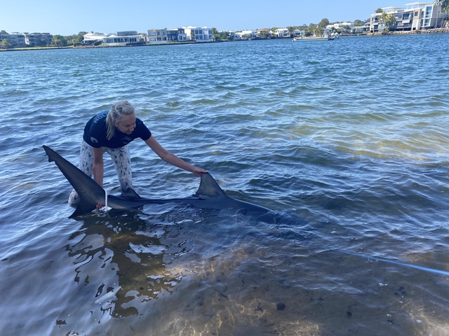
Bull shark tagging for improved education
Research led by University of the Sunshine Coast in partnership with NBRF and other partners is providing a greater understanding of bull shark activity across the Noosa and Sunshine Coast Biosphere Reserves.
UniSC marine scientist Dr Bonnie Holmes said the collaborative project aims to provide the Queensland Government Shark Control Program with evidence-based data and information to improve shark bite mitigation methods and water user education.
Tracking devices are being used to track bull sharks in the waterways of Noosa, Maroochy, Mooloolah Rivers and the northern Pumicestone Passage. Up to 80 Vemco acoustic tags are being deployed on individual sharks to correlate movements with environmental data.
“These detections allow us to monitor shark movements up and down the river, and we can then correlate the drivers of those movements with seasonal factors, like rainfall and current strength. In essence, we can then determine both critical habitat, and also calculate when sharks move into areas that are also high use for human activities like swimming and paddle boarding,” said Dr Holmes.
“Our larger Vemco tags have a battery life of over 10 years now, so we can monitor the bull sharks from juvenile stage through to adulthood – we may even track them long enough to see females return to the Noosa River to birth their own pups one day!”
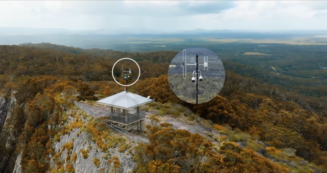
Firetech Connect: Building bushfire resilience through technology
The 2019 Peregian bushfires, which came perilously close to destroying Peregian Beach and other nearby suburbs, highlighted the need for new approaches to bushfire management in the Noosa Shire.
In response, council tasked its Peregian Digital Hub with finding ways that technology could contribute to bushfire resilience. Firetech Connect is a program to accelerate the development and adoption of new technologies which can help mitigate bushfire risk and build community resilience.
Firetech Connect is a collaborative initiative, bringing together a global network of technology companies, researchers, and emergency service agencies to trial and evaluate new solutions in a real-world setting.
A key aspect of the program is the Firetech Living Lab which provides a platform for testing and validating a range of technologies. Its Bushland Lab is where new technologies like drones, robotics, and sensor networks can be tested in a controlled bushfire environment. The Data Lab provides a platform for trialling and showcasing data-driven solutions for bushfire prediction, detection, analysis, and community information.
The Firetech Connect program has already conducted a number of successful trials with partner agencies, including the Queensland Fire & Emergency Services. It is establishing itself as a globally significant testbed for bushfire technology innovation, positioning Noosa at the forefront of this critical field.
The Firetech Connect program has attracted funding from federal and state governments and was recently awarded a grant by Advance Queensland for its Fire Air traffic Management trial, to help accelerate the use of drones in bushfire emergency response.
Learn more
Discover Noosa’s living laboratory inside the Noosa Biosphere Reserve, at noosabiosphere.org.au/living-laboratory